


lac daude_mt llaret

jcmartin
User
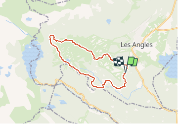

Length
14.2 km

Max alt
2367 m

Uphill gradient
632 m
Km-Effort
23 km

Min alt
1798 m

Downhill gradient
631 m
Boucle
Yes
Creation date :
2019-01-15 14:49:42.351
Updated on :
2020-08-02 09:18:12.561
4h46
Difficulty : Medium

FREE GPS app for hiking
 SityTrail
IGN / Geographical institutes
SityTrail Plus
The world is yours!
About
Trail Walking of 14.2 km to be discovered at Occitania, Pyrénées-Orientales, Les Angles. This trail is proposed by jcmartin.
Points of interest


Positioning
Country:
France
Region :
Occitania
Department/Province :
Pyrénées-Orientales
Municipality :
Les Angles
Location:
Unknown
Start:(Dec)
Start:(UTM)
423284 ; 4712740 (31T) N.
Comments